A look at the New Compass Solutions platform tools that make the Teleqo Tech I-95 corridor dataset usable across telecom, utility, and DOT workflows, all from the desktop on day one.
From data outputs to decisions
Mobile LiDAR and panoramic imagery data is one of the densest, richest pictures of an infrastructure corridor anyone can capture. It’s also one of the least usable, in its raw form, by the engineers and planners who need to act on it. A 1,920-mile, dual-direction point cloud and high-resolution panoramic imagery of the I-95 corridor contains an extraordinary amount of information, but a make-ready engineer, a DOT asset manager, or a state broadband office need the data transformed into digestible deliverables before they can begin their processes.
That’s the gap New Compass Solutions was built to close. Our two core platforms, Pathfinder for visualization and Ranger for automated extraction, turn the Teleqo Tech I-95 dataset into something every stakeholder along the corridor can actually use.
The source: a dataset built for the work
Teleqo Tech captured the I-95 corridor using a purpose-built mobile LiDAR survey vehicle equipped with a Riegl VMY-2 dual-head scanner and a Ladybug6 camera, conducting dual-pass collection, with every segment captured in both directions of travel. The result is centimeter-accurate, fully georeferenced 3D coverage of all 1,920 miles from Maine to Florida, with bilateral asset capture and redundant verification baked into the data itself.
That’s the source dataset Ranger and Pathfinder operate on. The quality of the field collection is what makes everything that follows possible; the role of our platforms is to turn that quality into operational intelligence.
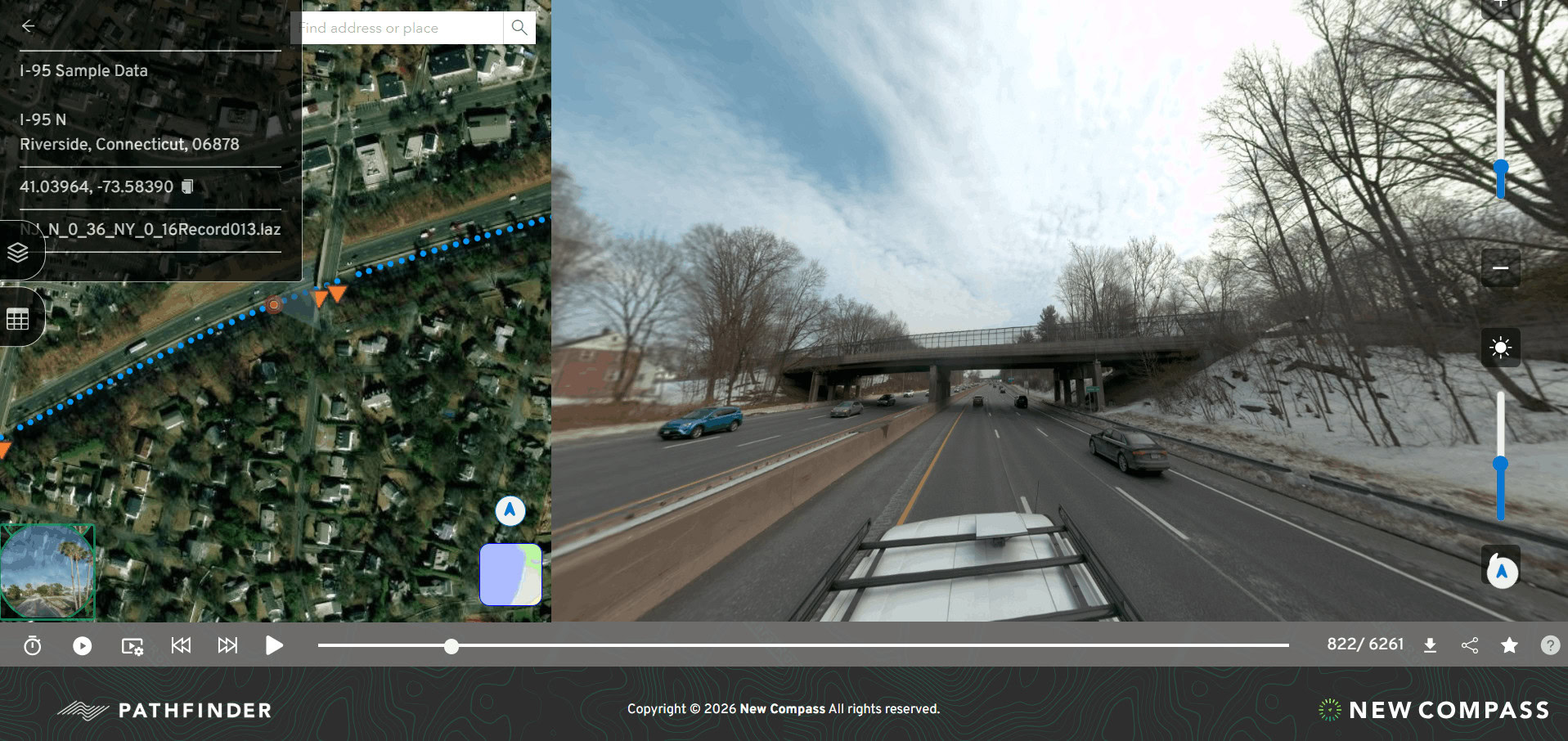
Pathfinder: visualization and corridor navigation
Pathfinder is the visualization layer of the New Compass platform. Designed for accessibility, it lets users navigate the I-95 corridor dataset through an intuitive 3D interface, virtually driving the corridor, pausing at any location, and examining the surrounding environment in precise detail without any specialized software.
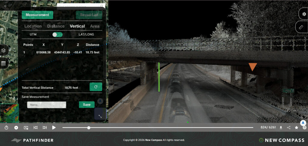
Pathfinder supports corridor-level review, targeted asset inspection, measurement and annotation tools, and collaborative workflows that let engineering teams, planners, and field crews work from a shared, authoritative view of the data. For clients licensing the I-95 dataset, that means immediate access to a visually rich, navigable representation of every mile of the corridor, enabling rapid desktop reconnaissance long before any field mobilization.
In practice: a broadband engineer can sit at their desk in Atlanta and inspect every utility pole between Richmond and Petersburg. A DOT planner in Trenton can review interchange geometry on a corridor segment in Connecticut. A utility operator can confirm vegetation clearances along a 30-mile stretch in the Carolinas without ever putting a truck on the road.

Ranger: automated extraction at corridor scale
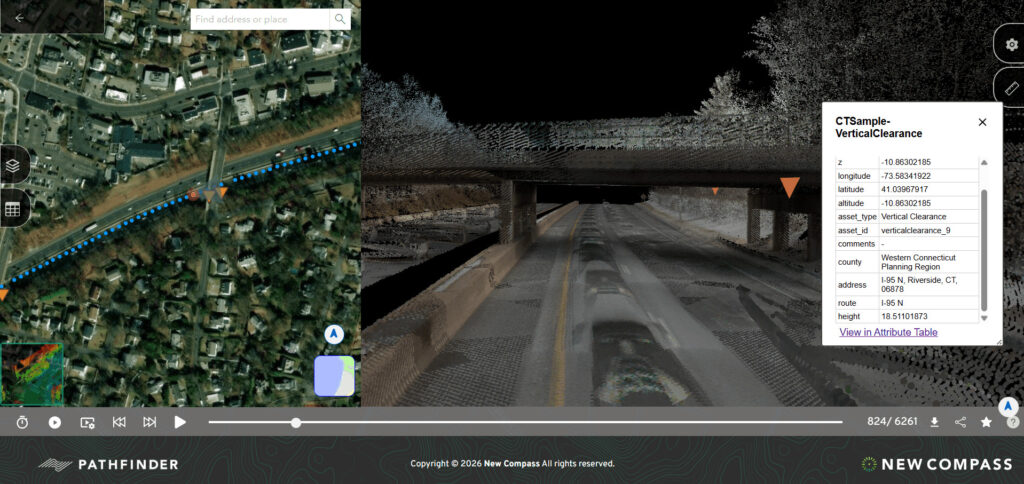
Where Pathfinder enables users see the data, Ranger lets users fully analyze it. Built on the Unity platform and engineered to work directly on processed point clouds, Ranger is the asset extraction and classification engine that turns the I-95 point cloud into structured, queryable asset records at corridor scale, across all 15 states, in formats engineering and asset-management systems can consume directly.
Ranger’s extraction modules are designed to detect a broad range of asset types with high accuracy, delivering attribute-rich records that export into GIS environments, asset management systems, and engineering workflows. Users can filter by asset type, segment by geography or jurisdiction, and export in standard formats, making the data directly usable inside the planning and maintenance platforms clients already run.
Ranger Extraction on Corridors
While Ranger’s fully customizable data dictionary allows users to build any line, point, or polygon extraction tool they may need, there are a few specific cases for the I-95 corridor that may stand out.
- Utility and telecom poles: every pole along the right-of-way, geolocated and attributed with height estimates, lean measurements, and classification by pole type, providing the foundation for make-ready engineering, pole loading analysis, and attachment permitting.
- Overhead lines and attachments: conductor and communications lines traced along the corridor, supporting clearance analysis, wire sag assessment, and inventory of existing telecom and power attachments, all of which is critical for BEAD-funded fiber deployments.
- Traffic signs and roadway signage: every regulatory, warning, informational, and guide sign along the corridor, with location, facing direction, mounting configuration, and estimated dimensions. Retroreflectivity degradation can be assessed through intensity analysis, supporting MUTCD-compliant sign management.
- Guardrail and safety hardware: guardrail systems, barrier walls, end treatments, and delineators extracted and classified across the corridor, supporting safety upgrade prioritization and crash-barrier maintenance for state DOTs.
- Vegetation and encroachment: areas of encroachment into the roadway clear zone, overhead canopy conflicts, and canopy-to-powerline proximity, a persistent risk factor for utility operators that the I-95 dataset helps proactively manage.
Applications across industries
Broadband and telecom
The I-95 corridor is one of the most important broadband expansion corridors in the country, and Federal BEAD funding is driving historic levels of fiber-to-the-premises and middle-mile investment along it. Ranger’s pole and attachment extractions support desktop make-ready engineering by assessing existing pole capacity for new fiber before construction begins, at hundreds of miles of corridor scale, formatted for direct integration with the GIS and OSP design platforms broadband teams already use. For state broadband offices administering BEAD allocations, the dataset provides a consistent geospatial baseline that spans state boundaries.
Utilities
Electric utilities can use the corridor dataset to assess line-to-vegetation clearances, identify poles approaching end-of-life based on lean and condition indicators, and model the scope of grid hardening and electrification upgrades. Gas and water utilities operating in or near the right-of-way can use Pathfinder for corridor-level reconnaissance and Ranger extractions to update asset records without mobilizing field crews. For utilities negotiating joint-use agreements, the high-resolution attachment data Ranger produces is an objective, third-party-validated record of existing conditions, a meaningful asset in dispute resolution and rate cases.
Transportation and DOTs
For the 15 state DOTs whose jurisdictions touch I-95, the dataset supports the full infrastructure management lifecycle. Sign-audit and replacement programs, driven by MUTCD retroreflectivity requirements, are one of the most immediate applications: Ranger can deliver a complete, geolocated sign inventory for any corridor segment in a fraction of the time and cost of traditional field audits. Beyond signage, the data supports pavement management, guardrail condition assessments, bridge-approach surveys, clear-zone analysis, and HD-mapping and digital-twin baselines that would otherwise take years and millions of dollars to build. For agencies working on connected and automated vehicle corridors, the dense, accurate point cloud is the raw material for map updating and lane-level geometry verification.
A platform built for the decisions that matter
The Teleqo Tech collection is the foundation. New Compass’s role is making that foundation operational: accessible, queryable, and immediately useful across the workflows that will define the eastern seaboard’s transportation, energy, and communications networks over the next decade.
With 1,920 miles of dual-pass Riegl VMY-2 data delivered through Pathfinder and Ranger, every stakeholder along the corridor, from broadband engineers in rural Virginia to DOT planners in Massachusetts to utility operators in Georgia, gets the same thing: a complete, consistent, and immediately actionable geospatial record, ready to go to work.
For a demonstration of Pathfinder and Ranger on the I-95 corridor dataset, contact the New Compass Solutions team.