
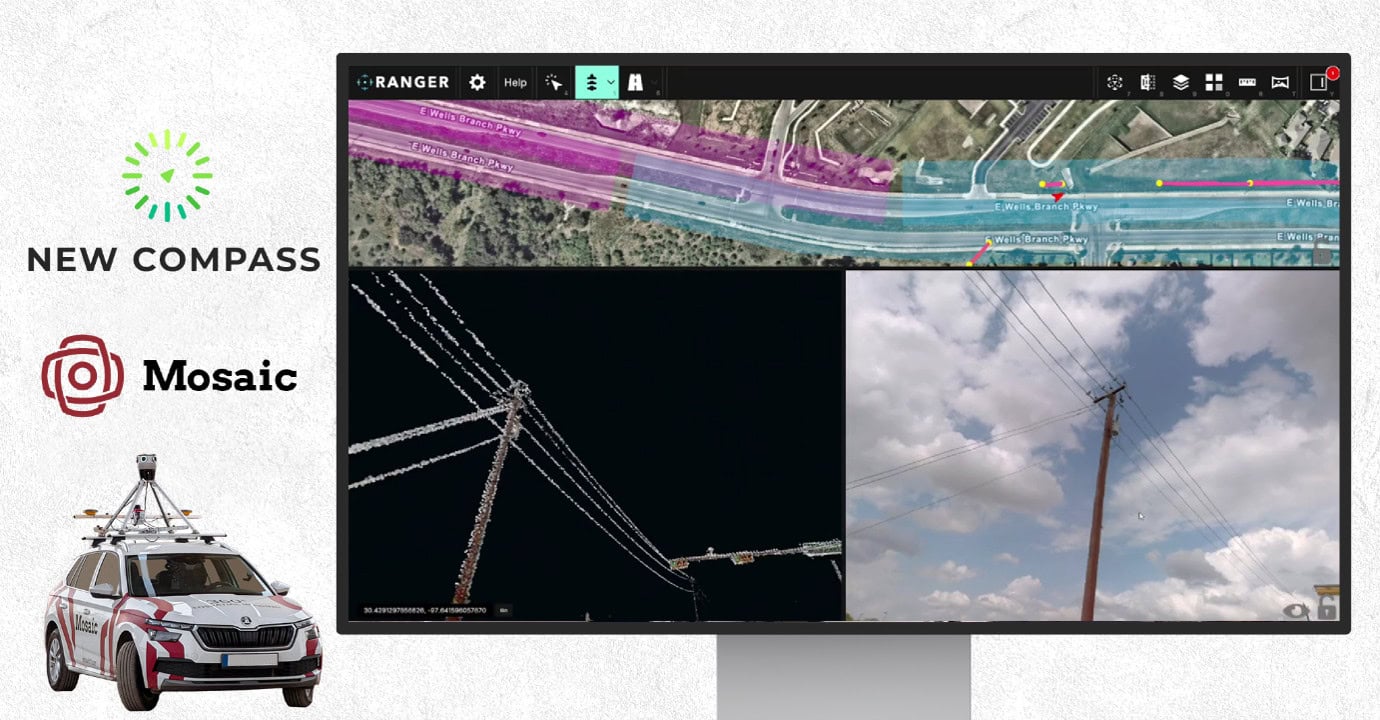
Providing a continent with reliable broadband internet takes high efficiency at every stage. Use Mosaic and New Compass to stretch your BEAD funding further.
In this article, we will walk you through the traditional vs. modern mobile mapping process for telecom companies, from the collection process to post-processing to final deliverables.
For planned fiber or broadband deployment projects, such as BEAD, the existing network information is often incomplete and not detailed enough for design or permitting decisions.
By collecting high-resolution mobile mapping data along the project corridor, teams can update their database with accurate, asset-level information. The goal is to create a shared source of ground truth that can be used by engineering, permitting, construction, and other stakeholders throughout the project’s lifecycle.
A workflow that uses Mosaic’s Meridian mobile mapping system and New Compass’s Ranger and Pathfinder programs provides the seamless hardware and software combination that keeps your broadband deployment on schedule and within budget.
What deliverables should you expect from telecoms surveying?
The final output should be a production-ready dataset that identifies, locates, and attributes the relevant telecom and utility infrastructure. This should include an accurate inventory of poles, attachments, spans, cabinets, pedestals, guy wires, anchors, clearance issues, vegetation overgrowth, and other assets or conditions relevant to the telecoms project.
A vectorized representation of the corridor is also important, in which key assets are extracted from imagery and LiDAR data and converted into usable GIS- or CAD-compatible features. The expected final deliverables may include:
- a pole and asset inventory,
- vectorized telecom and utility infrastructure layers,
- mapped pole locations and relevant attributes,
- extracted span and attachment information,
- identified clearance, access, and vegetation issues,
- GIS-ready or CAD-ready vector data,
- permit-supporting documentation and visual references, and/or
- a validated corridor model that can be reviewed by engineering, permitting, and construction teams.
This survey should provide the foundation for design decisions, make-ready planning, permit preparation, and future network management.
Traditional surveying: field collection estimates
Imagine a typical field setup that involves a 10-person survey team equipped with three high-quality GNSS/RTK receivers and two total stations. In practice, this would likely be organized into five two-person crews: three GNSS crews working in areas with good satellite visibility, and two total station crews covering locations where GNSS performance is limited by trees or buildings.
The crew’s objective is to survey every relevant utility pole with an absolute accuracy of about 3–5 cm. For each pole, the crew would need to record its position, capture several attributes, take photographs, assess the visible condition of the pole, and add environmental or safety-related notes where necessary. These notes could include observations such as damaged or leaning poles, overgrown vegetation, or access difficulty.
Under normal urban or suburban field conditions, a realistic production rate would be approximately:
8–12 minutes per pole per crew
This includes walking or driving between poles, setting up the measurement, capturing the point, taking photographs, recording attributes, and writing any necessary field notes.
With five crews working in parallel, the overall daily production rate would likely be:
approximately 150–170 fully documented poles per day
This assumes a well-organized field team, reasonable access conditions, and a normal mix of GNSS and total station work. It also assumes that the output is not just a measured point, but a documented field record for each pole.
For example, if the project corridor contains around 1,000 poles, the field survey alone would likely require:
approximately 6–7 productive field days
However, this does not include additional time for mobilization, route coordination, control setup, field QA, revisits, missed assets, or problematic locations. Once these are included, the total field effort would more realistically be:
approximately 8–10 field days for 1,000 poles
For larger projects, the effort would scale accordingly:
| Estimated number of poles | Traditional field survey duration |
| 500 poles | approximately 4–5 field days |
| 1,000 poles | approximately 8–10 field days |
| 2,500 poles | approximately 18–22 field days |
| 5,000 poles | approximately 35–45 field days |
This estimate only covers the field collection phase. It does not include office processing, data cleaning, CAD/GIS production, inventory creation, QA/QC, or final deliverable preparation.
The key point is that traditional pole surveying can produce highly accurate pole locations, but it requires significant field labor, multiple crews, repeated setup, direct access to each asset, and manual documentation at every pole.
In a telecom project with hundreds or thousands of poles, like those proposed by the BEAD program, the field effort can quickly become a major schedule and resource constraint.
Mobile mapping with Mosaic Meridian: field collection estimates
Using Mosaic Meridian, the field collection phase becomes a high-efficiency corridor capture operation rather than going pole-by-pole.
Instead of sending multiple survey crews to physically visit, measure, photograph, and document every pole, a Meridian-equipped vehicle would drive the planned telecom corridor and capture high-resolution 360° imagery and LiDAR continuously along the route.
In a well-planned corridor collection, a Meridian vehicle can realistically capture around 250 km of route per field day.
This assumes a drivable corridor, good project preparation, reasonable weather, and an efficient collection plan. Actual production may vary depending on traffic, road complexity, access restrictions, GNSS conditions, lighting, and whether certain sections require repeat passes.
How big of a field team do I need?
The Meridian field setup could be as small as one vehicle and one trained operator. This is much smaller than traditional surveying methods.
With Meridian, the field team is not creating the final pole inventory in the field. Instead, it captures the source dataset from which the pole inventory, vector model, asset attributes, and permit-relevant observations can be extracted later.
How many utility poles can Meridian survey in one day?
Assuming approximately 12 poles per mile (20 poles per kilometer) in a suburban telecom corridor, the following comparison can be used:
| Estimated number of poles | Traditional survey field duration | Meridian field collection duration |
| 500 poles | approximately 4–5 field days | within 1 field day |
| 1,000 poles | approximately 8–10 field days | within 1 field day |
| 2,500 poles | approximately 18–22 field days | approximately 1 field day |
| 5,000 poles | approximately 35–45 field days | approximately 1–2 field days |
How fast is turnaround time from data capture to usability?
A realistic operational model when working with the Meridian and New Compass would be:
Day 1: field collection
Day 2: post-processing
Day 3: imagery and point cloud available for extraction and review within Ranger and New Compass
This is a major advantage for telecom projects where teams need to move quickly from collection to engineering, inventory creation, and permitting preparation.
Why Mosaic Meridian is the right fit for telecoms
The best mobile mapping solution is the one that can be deployed quickly, capture the corridor efficiently, and produce clean, usable data. At every step of the mobile mapping process, Meridian has simplicity at the forefront.
Portable design
The entire system is easy to transport, making it practical for projects across different regions or countries. It can be flown with, shipped, and mobilized without the logistical complexity associated with larger mobile mapping systems (MMS).
The Mosaic X fits in a standard airport carry-on bag, and the Travel Mount folds down for easy storage and transportation.
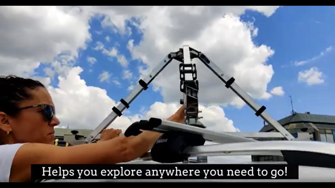
Caption: The Travel Mount is easy to set up and take down- portable too!
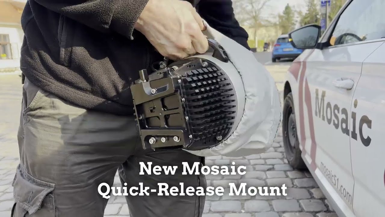
Caption: The Quick-Release Mount makes attaching the camera to the Travel Mount even simpler.
No specialized vehicles needed
It also does not require a dedicated survey vehicle. Meridian can be mounted on different vehicle types, allowing the project team to use a locally available car rather than transporting or maintaining a dedicated vehicle. This is a major benefit for telecom deployments across wide areas.
Simple field setup
A practical field setup can be completed in approximately 10–15 minutes, after which the operator can begin collecting imagery and LiDAR data. With Meridian, the answer is simple: one operator, one vehicle, and fast setup.
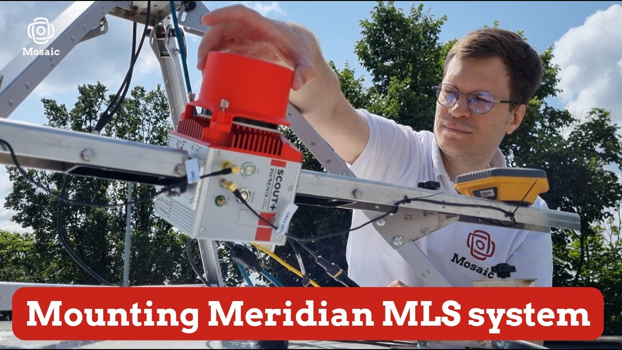
Caption: Follow our step-by-step guide on YouTube to see how easy it is to set up the Meridian and Meridian Lite.
Only needs one operator
As seen in the video above, Meridian can be operated by a single person, and training takes less than a day. This is a major difference from traditional survey workflows and a huge practical advantage over heavier or more complex MMS.
A single operator can:
- mount the Meridian system onto the vehicle,
- start the capture,
- drive the route,
- monitor data collection,
- check coverage, and
- complete the field operation.
Reducing the crew requirement from multiple survey teams to one operator and one vehicle creates a major operational advantage in both costs and time efficiency.
Remote monitoring and coverage reporting
Unlike in traditional surveying, with Mosaic the project manager does not need to wait for the operator to return from the field to understand what has been captured. From the office, the project manager can review the collected coverage, identify gaps, and generate a coverage report within minutes.
This makes the field operation more controlled and reduces delays.
Is a highly dense point cloud always better?
For this type of telecom corridor project, the best solution is not necessarily the MMS with the highest possible LiDAR density or the most complex survey configuration.
High-end mobile mapping systems from providers such as RIEGL and Leica are extremely powerful and often designed for demanding survey-grade applications that require very dense LiDAR data.
For example, RIEGL’s VMX-3HA is specified at up to 6 million measurements per second. Leica’s Pegasus TRK line similarly targets long-range mobile mapping, with configurations such as the TRK500 and TRK700 offering 4.4 million points per second.
For some applications, that level of density is necessary, but in a typical telecom inventory and permitting workflow, collecting that much data often results in unnecessarily high storage costs and data decimation.
Telecom projects need high-quality imagery, accurate asset positioning, enough LiDAR detail to support reliable extraction, and a dataset that can be processed, reviewed, and delivered quickly.
Meridian provides a much more practical balance for this use case.
Meridian combines high-resolution 360° imagery with the Phoenix Scout-M2X LiDAR system that collects 800,000 points per second with 3 returns. The 2–5 cm accuracy for both imagery and point clouds is important for telecom because many critical decisions are visual as much as geometric: pole identification, attachments, vegetation growth, visible damage, access issues, and the pole’s position within the context of the entire area.
How to balance LiDAR point cloud density with usability
For telecom inventory, extremely dense point clouds are not always the most efficient answer. Very high point density creates massive datasets that are slower to process, transfer, and manage, without adding much more useful information.
Meridian provides accurate point clouds with enough detail to support asset extraction and vector modeling, but without producing unnecessary point density that slows down the workflow.
The result is a dataset that remains visually clear, geometrically reliable, and easier to use for semi-automated or automated extraction.
Read Mosaic’s article With LiDAR, Sometimes Less is More for a full breakdown of the density vs. usability debate with LiDAR.
Meridian, Ranger, and Pathfinder
Once you’ve captured the telecoms corridor data, the Meridian imagery and LiDAR data can move directly into the New Compass software environment, where the actual telecom extraction and delivery workflow takes place.
The process looks like this:
Capture with Mosaic Meridian → Extract in Ranger → Review and deliver through Pathfinder
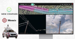
Ranger: a cloud-based extraction platform built on the Unity engine
Once LAZ and panoramic images are processed, they are uploaded to Ranger, New Compass’s cloud-based asset extraction platform. All project members access and work from the same dataset in the cloud, eliminating the need to move large files to local workstations.
Ranger runs on the Unity real-time 3D engine, giving it the rendering performance to navigate dense, colorized point clouds fluidly at production scale. There is no local installation or hardware dependency. Extractors, QA reviewers, client engineers, and partner firms all work from their laptops, and updates deploy platform-wide without disrupting active work.
Project management designed for make-ready pace
New Compass built Ranger after years of running make-ready projects, and the project management layer reflects that experience directly.
First, Ranger’s project can be organized by hubs, or bucketized sections of collected data. Project workflows are organized by hub, which allows for the seamless and consistent movement of data through the make-ready workflow. As extractors finish hubs, they are delivered to the client for the continuation of the design process.
Additionally, Ranger was built so that multiple organizations can collaborate in the same project simultaneously. Partner firms can be added on short notice when workloads spike, and permissions are scoped by role so each party accesses only what their function requires.
Finally, Ranger’s data dictionary builder allows for the configuration of extraction tools to exactly match the desired outputs. The data dictionary is set before extraction begins, and this locks in field names, asset types, allowed values, and output formats. The dictionary is structured to map the exported shapefile directly into the client’s downstream CAD environment, with no manual reformatting required.
Dual Viewshed: point cloud and panoramic imagery, simultaneously
LiDAR tells you where something is. Panoramic imagery tells you what it is. Ranger surfaces both in a single interface.
Extractors work in the colorized point cloud for geometry (attachment heights, span lengths, midspan sag, lean direction and magnitude) while referencing linked 360° imagery to confirm attachment types and resolve ambiguous geometry. The dual viewshed is particularly valuable in situations like overgrown rural backroads, where vegetation obscures geometry in the point cloud but the panoramic record provides a clear view from a different angle. Condition assessments are captured in the same workflow, without a separate review pass.
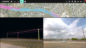
Caption: Ranger’s dual view allows extractors to view the point cloud and pano images simultaneously for more detailed extraction.
Semi-automated extraction tools
Ranger automates geometry while keeping the extractor in control of attachment type determination and attribution decisions.
A single click on a pole auto-populates circumferences, diameters, lean direction, lean magnitude, and height. Selecting two poles and running the Span tool generates span length automatically, linked to both pole IDs. The Midspan tool follows each wire’s catenary geometry between two poles and identifies the sag point and height for every wire. Pole attachments can be extracted individually by click or in bulk via the Midspan tool. Anchors are extracted with a click and auto-calculate the lead distance to the pole base. All assets are linked to their corresponding pole IDs, building a connected network across the project.
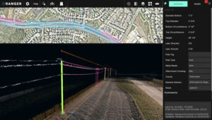
Caption: Ranger’s semi-automated tools mean less mouse clicks and measurements for extractors.
Shapefile export: ready for CAD import
When extraction is finished in a hub, assets are exported as shapefiles structured around the client’s data dictionary and formatted for direct import into their engineering tools. This eliminates the need for additional re-working of the data after delivery to the client, which can lead to human errors and extended timelines. Shapefile attribute tables can be changed mid-project to ensure alignment with any new tools that clients are using in their workflow.
Pathfinder: a visualization platform to explore the collected and extracted datasets
Pathfinder is New Compass’s cloud-based visualization platform that overlays extracted assets with the collected point cloud and imagery. It is the perfect tool for clients to analyze all of their data at once. Engineers can review the point cloud and imagery to understand their entire pole network without leaving their desk. They can examine extracted poles directly within the point cloud.
Pathfinder allows them to take any measurements they may need for additional examination, as well as share annotations directly within the platform that aggregates all project deliverables across hubs and delivery phases into one place. Pathfinder allows users to understand the full context of their delivered data instead of only viewing shapefiles in a static 2D environment.
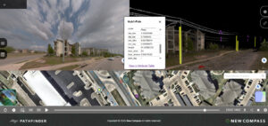
Caption: Pathfinder’s visualization platform allows users to view extracted assets directly within their collected LiDAR and panoramic imagery for added context.
A workflow built to connect
The make-ready extraction workflow sits between Mosaic’s field collection upstream and the fiber network design downstream. Ranger serves as the production layer in the middle: ingesting LiDAR and panoramic data, extracting and attributing it at pace, and delivering it in a format ready for the next phase. The result is a workflow where each step connects cleanly to the next, from collection through extraction through design.
Ready to upgrade your telecoms surveying to a Mosaic Meridian MMS?
Contact the Mosaic team here.
Interested in seeing how Ranger and Pathfinder support your make-ready workflow?
Reach out to the New Compass team for a demo!